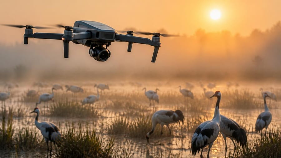
Wildlife conservationists face an uphill battle when tracking endangered bird species across vast, inaccessible terrains. Traditional methods—ground surveys, manual nest checks, and manned aircraft flyovers—are labor-intensive, costly, and often disruptive to the very creatures researchers aim to protect. Now, a new generation of autonomous drones powered by artificial intelligence is reshaping how scientists monitor avian populations, offering real-time data collection with minimal environmental impact.
From remote islands to dense forest canopies, these flying platforms are proving that technology can be a powerful ally in the fight against extinction. By pairing computer vision algorithms with aerial mobility, conservation teams can identify nests, count individuals, and even detect poaching threats—all without setting foot in sensitive habitats.
The mechanics of drone-based monitoring
Modern conservation drones integrate several layers of technology. High-resolution cameras capture imagery at multiple wavelengths, including infrared, which helps distinguish warm-blooded birds from surrounding vegetation. Onboard processors run machine-learning models trained on thousands of annotated bird images, enabling the system to recognize species, estimate age classes, and flag unusual behavior patterns in real time.
Unlike earlier remote-sensing tools, today's platforms operate autonomously along pre-programmed flight paths, reducing the need for skilled pilots in the field. GPS waypoints guide the drone over nesting colonies or foraging zones, while obstacle-avoidance sensors prevent collisions with trees or cliffs. Data streams directly to cloud servers, where biologists can review findings within hours rather than weeks.
Key advantages of drone AI in avian conservation include:
- Minimal disturbance to nesting sites and breeding behavior
- Rapid coverage of large or rugged areas
- Continuous monitoring during critical life stages
- Lower operational costs compared to helicopter surveys
- Scalability across multiple conservation sites
Case studies in the field
Several pilot programs demonstrate the practical impact of drone AI. In the Pacific Northwest, researchers deployed drones over coastal seabird colonies to count marbled murrelets, a threatened species that nests high in old-growth conifers. Traditional ground surveys often missed nests hidden in dense canopy, but thermal imaging from above revealed heat signatures of incubating adults, improving population estimates by more than 30%.
On Caribbean islands, conservationists use drone patrols to protect critically endangered parrots from illegal trapping. AI algorithms scan live video feeds for human activity near known roost sites, triggering alerts that allow rangers to respond before poachers can strike. Early results show a measurable decline in trapping incidents across monitored zones.
Drones give us eyes where we've never had them before, and the AI ensures we don't miss what matters most in thousands of hours of footage.
In sub-Saharan Africa, drone surveys track the movements of vulture populations, whose numbers have plummeted due to poisoning and habitat loss. By mapping foraging ranges and identifying carcass sites, scientists can pinpoint high-risk areas and work with local communities to reduce conflict with livestock farmers.
Challenges and ethical considerations
Despite their promise, drone systems are not without limitations. Battery life restricts flight duration to roughly 30 minutes per sortie, forcing teams to plan missions carefully or deploy multiple units in relay. Inclement weather—high winds, heavy rain, or dense fog—can ground operations for days, delaying time-sensitive data collection.
Privacy and regulatory hurdles also loom large. In many jurisdictions, drone flights over protected areas require permits from multiple agencies, and airspace restrictions near airports or military zones can complicate logistics. Conservationists must balance the need for comprehensive coverage with respect for local landowners and indigenous communities whose territories overlap with critical habitats.
There is also the question of AI reliability. Machine-learning models trained on datasets from one region may struggle to recognize plumage variations or behavioral cues in distant populations. False positives—misidentifying a rock formation as a nest, for example—can waste field resources, while false negatives risk overlooking vulnerable individuals. Continuous model refinement and cross-validation remain essential.
Integration with broader conservation strategies
Drone AI works best when embedded in a holistic conservation framework. Data collected from aerial surveys inform habitat restoration projects, guide the placement of protective fencing, and help prioritize areas for legal designation as wildlife refuges. When combined with satellite imagery and citizen-science observations, drone findings provide a multi-layered picture of ecosystem health.
Collaboration between technology developers and field biologists is critical. Engineers must understand the nuances of avian behavior—flight patterns, nesting chronology, response to disturbance—to design systems that maximize data quality without causing harm. Biologists, in turn, need training to interpret AI-generated outputs and troubleshoot hardware in remote settings.
| Conservation challenge | Drone AI solution | Measurable outcome |
|---|---|---|
| Population census in rugged terrain | Autonomous transect flights with thermal imaging | 30% increase in nest detection accuracy |
| Anti-poaching enforcement | Real-time activity alerts via computer vision | Reduction in illegal trapping incidents |
| Habitat-use mapping | Multi-spectral imagery + GPS tracking | Identification of critical foraging zones |
Looking ahead: scalability and innovation
As drone hardware becomes cheaper and AI models grow more sophisticated, the barrier to entry for conservation organizations continues to fall. Open-source software platforms allow smaller nonprofits to customize algorithms for local species, while cloud-based analytics enable global collaboration on data interpretation.
Emerging capabilities—such as acoustic sensors that identify bird calls, or swarm drones that coordinate flights across multiple sites—promise even greater efficiencies. Researchers are also exploring hybrid approaches that pair drones with ground-based camera traps and GPS tags, creating a comprehensive surveillance network that captures behavior at multiple scales.
Yet technology alone will not reverse biodiversity loss. Effective conservation demands policy reform, community engagement, and sustained funding. Drones are a tool, not a panacea, and their success hinges on the willingness of stakeholders to act on the data they provide.
This information does not replace advice from a qualified conservation biologist or wildlife management professional. Always consult local regulations and experts before conducting drone operations in protected areas.